Файл:2022 Russian invasion of Ukraine.svg

Оріґіналный файл (SVG-файл, номінално 2199 × 1478 пікселів, розмір файлу: 3,72 МБ)
Rules for editing the map
|
| Любая учетная запись, ведущая войну правок или добавляющая версию без ссылки на источники, будет тут же заблокирована. Любые изменения должны обсуждаться на странице обсуждения страницы. |
Попис

|
This file may be updated to reflect new information. If you wish to use a specific version of the file without new updates being mirrored, please upload the required version as a separate file. |
| Опис |
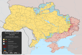
English: російське вторгнення в Україну (з 2022) – вторгнення російських військ на Україну, що розпочався 24 лютого 2022 року [] |
||
| Датум | 24 фебруара 2022 (перша версія) | ||
| Жрідло |
Власний твір заснований на: Russo-Ukrainian conflict (2014-2022).svg від Rr016 & Ukraine adm location map improved.svg від Yakiv Gluck
|
||
| Автор | Viewsridge | ||
| Іншы верзії |
[]
|
||
| SVG розвиток | Вихідний код цього SVG-файлу правильний. Це векторне зображення було створено з допомогою Inkscape. Этот файл переведён с использованием элементов переключения ( switch) формата SVG: все переводы хранятся в самом файле.
|


.gif)

.gif)


_en.png)
_vi.png)
_ru.png)
.svg)
This file is translated using SVG <switch> elements. All translations are stored in the same file! Learn more.
For most Wikipedia projects, you can embed the file normally (without a To translate the text into your language, you can use the SVG Translate tool. Alternatively, you can download the file to your computer, add your translations using whatever software you're familiar with, and re-upload it with the same name. You will find help in Graphics Lab if you're not sure how to do this. |
Ліценцованя
- Можете слободно:
- здїляти – копіровати, росшырёвати ці передавати дїло
- модіфіковати – адаптовати дїло
- За наступных подмінок:
- узнаня авторства – Мусите увести авторство такым способом, якым то пожадує автор або ліценсор (але не такым способом, котрый бы назначовав, же підпорують вас або ваше схоснованя дїла)
- захованя ліценції – Кідь тото дїло зміните, переведете до іншой подобы або схоснуєте як основу далшого дїла, можете дїло в резултатї шырити лем під тов самов подобов або подобнов ліценціов як є тота.
Історія файлу
Кликнути на датум/час, жебы видїти, як тогды вызерав файл.
| Датум/час | Мініатура | Розмір обєкта | Хоснователь | Коментарь | |
|---|---|---|---|---|---|
| актуална | 22:47, 16 мая 2024 | | 2199 × 1478 (3,72 МБ) | Physeters | Updates in Kharkiv Oblast per the ISW |
| 06:40, 14 мая 2024 |  | 2199 × 1478 (3,72 МБ) | Physeters | fix Derhachi | |
| 07:36, 13 мая 2024 |  | 2199 × 1478 (3,72 МБ) | Alexiscoutinho | Updated Vovchansk per detailed map | |
| 04:49, 13 мая 2024 |  | 2199 × 1478 (3,72 МБ) | Physeters | Updates per the ISW; for future reference, sources (like SuriyakMaps) must first have their reliability vetted on the talk page before they can be used to update the map; at the moment, the only two verified sources are the ISW and the Detailed Map on Wikipedia | |
| 12:34, 12 мая 2024 |  | 2199 × 1478 (3,31 МБ) | BlackShadowG | File uploaded using svgtranslate tool (https://svgtranslate.toolforge.org/). Added translation for zh-tw. | |
| 10:46, 12 мая 2024 |  | 2199 × 1478 (3,31 МБ) | Miki1234568 | File uploaded using svgtranslate tool (https://svgtranslate.toolforge.org/). Added translation for pl. | |
| 09:54, 12 мая 2024 |  | 2199 × 1478 (3,31 МБ) | BlackShadowG | File uploaded using svgtranslate tool (https://svgtranslate.toolforge.org/). Added translation for zh-cn. | |
| 01:02, 12 мая 2024 |  | 2199 × 1478 (3,71 МБ) | Mattia332 | As per Renowned Unbiased Open Source "SuriyakMaps", Russian progress in Kharkov | |
| 21:38, 10 мая 2024 |  | 2199 × 1478 (3,71 МБ) | Physeters | add date marker | |
| 21:31, 10 мая 2024 |  | 2199 × 1478 (3,71 МБ) | Physeters | Update per the ISW; Russia re-enters northern Kharkiv Oblast |
Хоснованя файлу
Далша сторінка ся одказує на тот файл:
Ґлобалне хоснованя файлу
Тот файл хоснують такы іншы вікі:
- Хоснованя на af.wikipedia.org
- Хоснованя на als.wikipedia.org
- Хоснованя на am.wikipedia.org
- Хоснованя на ang.wikipedia.org
- Хоснованя на an.wikipedia.org
- Хоснованя на ar.wikipedia.org
- Хоснованя на ary.wikipedia.org
- Хоснованя на arz.wikipedia.org
- Хоснованя на ast.wikipedia.org
- Хоснованя на azb.wikipedia.org
- Хоснованя на az.wikipedia.org
- Хоснованя на bat-smg.wikipedia.org
- Хоснованя на bcl.wikipedia.org
- Хоснованя на be-tarask.wikipedia.org
- Хоснованя на be.wikipedia.org
- Хоснованя на bg.wikipedia.org
- Хоснованя на bh.wikipedia.org
- Хоснованя на bn.wikipedia.org
- Хоснованя на br.wikipedia.org
- Хоснованя на bs.wikipedia.org
- Хоснованя на bxr.wikipedia.org
Указати ґлобалне схоснованя того файлу.